Canary Wharf in the context of "East London"

Play Trivia Questions online!

or

Skip to study material about Canary Wharf in the context of "East London"

Ad spacer

⭐ Core Definition: Canary Wharf

Canary Wharf is a privately owned financial district in London, England, located in the Isle of Dogs in the London Borough of Tower Hamlets. The Greater London Authority defines it as part of London's central business district. With the City of London and the West End, it constitutes one of the main financial centres in the United Kingdom and the world, containing many major global companies and banks' headquarters and high-rise buildings, including the third-tallest in the UK, One Canada Square.

The district was developed on the site of the former West India Docks in East London. Canary Wharf, together with Heron Quays and Wood Wharf, forms the Canary Wharf Estate, covering around 97 acres (39 ha).

↓ Menu

>>>PUT SHARE BUTTONS HERE<<<

👉 Canary Wharf in the context of East London

East London is the part of London, England, east of the ancient City of London and north of the River Thames as it begins to widen. East London developed as London's docklands and the primary industrial centre. The expansion of railways in the 19th century encouraged the eastward expansion of the East End of London and a proliferation of new suburbs. The industrial lands of East London are today an area of regeneration, which are well advanced in places such as Canary Wharf and ongoing elsewhere.

↓ Explore More Topics
In this Dossier

Canary Wharf in the context of Docklands Light Railway

The Docklands Light Railway (DLR) is an automated light metro system primarily serving the redeveloped Docklands area of London and providing a direct connection between London's two major financial districts, Canary Wharf and the City of London. First opened on 31 August 1987, the DLR has been extended multiple times, giving a total route length of 38 km (24 miles). Lines now reach north to Stratford, south to Lewisham, west to Tower Gateway and Bank in the City of London financial district, and east to Beckton, London City Airport and Woolwich Arsenal. An extension to Thamesmead is currently being proposed.

Normal operations are automated, so there is minimal staffing on the 149 trains (which have no driving cabs) and at major interchange stations; the four below-ground stations are staffed, to comply with health and safety regulations for underground stations. The DLR was one of the first major railway infrastructure projects in Britain where access for disabled people was considered, with level access into the train from platforms and lifts at all stations.

↑ Return to Menu

Canary Wharf in the context of London Docklands

London Docklands is an area of London encompassing the city’s former docks. It is located in inner east and southeast London, in the boroughs of Southwark, Tower Hamlets, Lewisham, Newham and Greenwich. The docks were formerly part of the Port of London, at one time the world's largest port. After the docks closed, the area had become derelict and poverty-ridden by the 1980s. The Docklands' regeneration began later that decade; it has been redeveloped principally for commercial and residential use. The name "London Docklands" was used for the first time in a government report on redevelopment plans in 1971 and has since been almost universally adopted. The redevelopment created wealth, but also led to some conflict between the new and old communities in the area.

↑ Return to Menu

Canary Wharf in the context of London City Airport

London City Airport (IATA: LCY, ICAO: EGLC) is an international airport in London, England. It is located in the Royal Docks in the Borough of Newham, about six miles (ten kilometres) east of the City of London and three miles (five kilometres) east of Canary Wharf. These are the two centres of London's financial industry, which is a major user of the airport. The airport was developed by the engineering company Mowlem between 1986 and 1987. The airport is owned and operated by London City Airport Limited.

London City Airport has a single 1,508-metre-long (4,948 ft) runway, and a CAA Public Use Aerodrome Licence (Number P728) that allows flights for the public transport of passengers; this licence also allows training flights, but only for the purpose of training pilots to operate at this specific airport. Only multi-engine, fixed-wing aircraft up to Embraer E195-E2, Airbus A220 and A318 size, with special aircrew and aircraft-certification to fly 5.5° approaches, strict noise limitations and further restrictions are allowed to conduct operations at London City Airport. As of 2020, the airport is about 60 hectares (150 acres) in size.

↑ Return to Menu

Canary Wharf in the context of FTSE Group

FTSE International Limited trading as FTSE Russell (/ˈfʊtsi/ "Footsie") is a British provider of stock market indices and associated data services, wholly owned by the London Stock Exchange (LSE) and operating from premises in Canary Wharf. It operates the well known UK FTSE 100 Index as well as a number of other indices. FTSE stands for Financial Times Stock Exchange.

↑ Return to Menu

Canary Wharf in the context of List of tallest buildings and structures in London

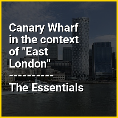
London, the capital and largest city of the United Kingdom, has 128 completed buildings that are at least 100 metres (328 feet) tall as of 2025, 42 of which have a height greater than 150 metres (492 ft). London has one of the largest skylines in Europe; it has the most skyscrapers taller than 150 m (492 ft) in the United Kingdom and in Western Europe, and the third most of any city in Europe overall, after Moscow and Istanbul. London's skyline has undergone immense transformation in the early 21st century. Since 2013, the tallest building in London and the United Kingdom has been The Shard, the only supertall skyscraper. The pyramid-shaped building in Southwark rises to a height of 306 m (1,004 ft). London has two primary skyscraper clusters: the City of London in central London, and Canary Wharf with the Isle of Dogs in East London, alongside numerous smaller groupings throughout Greater London.

For two centuries since 1710, St Paul's Cathedral was the tallest structure in London. While early skyscrapers sprouted in the late 19th and early 20th century in the United States, London—then the world's largest city—avoided this trend. In 1894, after work on the 12-storey Queen Anne’s Mansions, the London Building Act imposed a height limit of 30 m (98 ft) or less across the city. This restriction was lifted in the 1950s, permitting the construction of high-rises taller than St. Paul's. The destruction during The Blitz allowed more room for modern development. Early skyscrapers were built on the west side of central London, most notably the BT Tower in Fitzrovia in 1965. A concentration of tall buildings arose in the City of London, including office towers such as St Helen's and Tower 42, and Barbican Estate, a three-towered residential complex that is a prominent example of brutalism. The London Docklands in the Isle of Dogs, which had become disused in the 1960s, underwent a significant redevelopment plan in the 1980s, resulting in the financial district of Canary Wharf. Among the first skyscrapers built there was One Canada Square in 1991. At 236 m (774 ft), it surpassed Tower 42 to be London's tallest building; it is currently the city's third-tallest building and still the tallest in Canary Wharf.

↑ Return to Menu

Canary Wharf in the context of Waterloo Bridge

Waterloo Bridge (/ˌwɔːtəˈl/) is a road and foot traffic bridge crossing the River Thames in London, between Blackfriars Bridge and Hungerford Bridge and Golden Jubilee Bridges. Its name commemorates the victory of the British, Dutch and Prussians at the Battle of Waterloo in 1815. Thanks to its location at a strategic bend in the river, the bridge offers good views of Westminster, the South Bank and the London Eye to the west, and of the City of London and Canary Wharf to the east.

The bridge was given Grade II* listed structure protection in 1981.

↑ Return to Menu

Canary Wharf in the context of Bow Creek (England)

Bow Creek is a 2.25-mile (3.6 km) long tidal estuary of the English River Lea and is part of the Bow Back Rivers. Below Bow Locks the creek forms the boundary between the London Boroughs of Newham and Tower Hamlets, in East London.

↑ Return to Menu

Canary Wharf in the context of Rotherhithe

Rotherhithe (/ˈrɒðərhð/ RODH-ər-hydhe) is a district of South London, England, and part of the London Borough of Southwark. It is on the south bank of a bend in the Thames, facing Wapping, Shadwell and Limehouse on the north bank, with the Isle of Dogs to the east. It borders Bermondsey to the west and Deptford to the south-east. The district is a part of the Docklands area.

Rotherhithe has a long history as a port, with Elizabethan shipyards and working docks until the 1970s. In the 1980s, the area along the river was redeveloped as housing through a mix of warehouse conversions and new-build developments. The Jubilee line was extended to the area in 1999, giving fast connections to the West End and to Canary Wharf; the East London underground line was converted to part of the London Overground network in 2010, which provides easy access to the City of London. As a result, Rotherhithe is now a gentrifying residential and commuter area, with urban regeneration progressing around Deal Porter Square at Canada Water; a new town centre with restaurant and retail units, as well as new residential developments, is emerging here around the existing freshwater dock and transport hub.

↑ Return to Menu