Guna people in the context of "Guna de Wargandí"

Play Trivia Questions online!

or

Skip to study material about Guna people in the context of "Guna de Wargandí"


⭐ Core Definition: Guna people

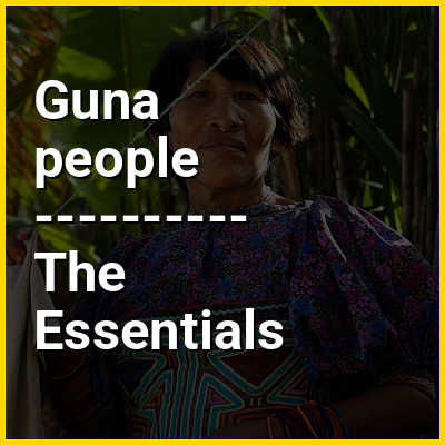
The Guna (also spelled Kuna or Cuna) are an Indigenous people of Panama and Colombia. Guna people live in three politically autonomous comarcas or autonomous reservations in Panama, and in a few small villages in Colombia. There are also communities of Guna people in Panama City, Colón, and other cities. Most Guna live on small islands off the coast of the comarca of Guna Yala known as the San Blas Islands. The other two Guna comarcas in Panama are Guna de Madugandí and Guna de Wargandí. They are Guna-speaking people who once occupied the central region of what is now Panama and the neighboring San Blas Islands and still survive in marginal areas.

In the Guna language, they call themselves Dule or Tule, meaning "people", and the name of the language is Dulegaya, literally "people-mouth". The term was in the language itself spelled Kuna prior to a 2010 orthographic reform, but the Congreso General de la Nación Gunadule since 2010 has promoted the spelling Guna.

↓ Menu

👉 Guna people in the context of Guna de Wargandí

Guna de Wargandí or Wargandí, formerly known as Kuna de Wargandí (Spanish pronunciation: [ˈkuna ðe waɾˈɣandi]) is a comarca indígena (indigenous territory) and corregimiento in Pinogana District, Darién Province, Panama with a population of 1,914 as of 2010. It was created by Law 34 of July 25, 2000, from the province of Darién, from the district of Pinogana. It has an area of 775 square kilometres (299 sq mi). It is inhabited by the Guna people.

↓ Explore More Topics
In this Dossier

Guna people in the context of San Blas Islands

The San Blas Islands of Panama is an archipelago comprising approximately 365 islands and cays, of which 49 are inhabited. They lie off the north coast of the Isthmus of Panama, east of the Panama Canal. A part of the comarca (district) Guna Yala along the Caribbean coast of Panama, it is home to the Kuna people.

San Blas and its surrounding area is a haven for ecotourism because of its pristine environs. The area is also popular for sailing, as it is known for its beauty and lack of hurricanes. Notable locations in the Archipelago are the main capital Gaigirgordub, the densely crowded island village of Carti Sugtupu, and the two keys, Cayos Limones, and Cayos Holandeses, both renowned for their clear waters.

↑ Return to Menu

Guna people in the context of Guna Yala

9°17′46″N 78°20′39″W / 9.29611°N 78.34417°W / 9.29611; -78.34417

Guna Yala, also known as Kuna Yala or by its former name San Blas, is a comarca indígena (indigenous province) in northeast Panama. Guna Yala is home to the indigenous people known as the Gunas. Its capital is Gaigirgordub. It is bounded on the north by the Caribbean Sea, on the south by the Darién Province and Emberá-Wounaan, on the east by Colombia, and on the west by the province of Colón.

↑ Return to Menu

Guna people in the context of Carti Sugtupu

Gardi Sugdub, also spelled Cartí Sugtupu, is an island in the San Blas Archipelago in the Panamanian comarca indígena of Guna Yala, 400m long and 150m wide. It is the southernmost and largest of four populated Carti Islands (the others are Cartí Tupile in the north, Carti Yandup in the west, and Carti Muladub in the east), and lies 1200 meters off the northern coast of mainland Panama. The island houses a small harbour and a museum, as well as a now-disused schoolhouse. Its indigenous inhabitants are Guna.

Discussions of relocation to a site on the mainland thanks to overpopulation on the island were first raised by Guna elders in 2008. The Panamanian government constructed the new village of Isber Yala between 2015 and 2024, construction being delayed due to funding issues, and following its completion in June 2024, 300 families moved from Gardi Sugdub into the new village.

↑ Return to Menu

Guna people in the context of Cayos Limones

The Cayos Limones or Lemon Keys are a group of Caribbean islands in the San Blas Archipelago in Guna Yala province of Panama. As part of the autonomous Guna Yala indigenous territory it is mainly populated by the Guna indigenous People. The islands in Cayos Limones are sparsely populated. The most notable of the islands are Isla de Perro and Chichimen, both are situated near substantial reefs making them ideal for snorkeling, as they contain several sunken ships. The economy is mainly based on tourism, fishing and coconut harvesting. The Keys are connected to the other islands of the archipelago and to the mainland by taxi-boat, normally through the other islands of El Porvenir or Carti Sugtupu.

↑ Return to Menu

Guna people in the context of Indigenous peoples of Panama

The Indigenous peoples of Panama, also known as Native Panamanians, are the original inhabitants of Panama, are the Native peoples whose history in the territory of today's Panama predates Spanish colonization. As of the 2023 census, Indigenous peoples constitute 17.2% of Panama’s population of 4.5 million, totaling just over 698,000 individuals. There are 7 indigenous peoples. The Ngäbe and Bokota comprise half of the Indigenous peoples of Panama.

Many of the Indigenous Peoples live on comarca indígenas, which are administrative regions for areas with substantial Indigenous populations. Three comarcas (Comarca Emberá-Wounaan, Guna Yala, Ngäbe-Buglé) exist as equivalent to a province, with two smaller comarcas (Guna de Madugandí and Guna de Wargandí) subordinate to a province and considered equivalent to a corregimiento (municipality).

↑ Return to Menu

Guna people in the context of Darién Gap

The Darién Gap (UK: /ˈdɛəriən, ˈdær-/, US: /ˌdɛəriˈɛn, ˌdɑːr-, dɑːrˈjɛn/, Spanish: Tapón del Darién [taˈpon del daˈɾjen]) is a remote, roadless, and dangerous area of rainforest on the international border between Colombia and Panama. Stretching across southern Panama's Darién Province and the northern portion of Colombia's Chocó Department, it acts as a natural barrier between North America and South America. Consisting of a large drainage basin, dense rainforest, and mountains, it is known for its remoteness, difficult terrain, and extreme environment, with a reputation as one of the most inhospitable regions in the world. Nevertheless, as the only land bridge between North America and South America, the Darién Gap has historically served as a major route for both humans and wildlife.

The geography of the Darién Gap is highly diverse. The Colombian side is dominated primarily by the river delta of the Atrato River, which creates a flat marshland at least 80 km (50 mi) wide. The Tanela River, which flows toward Atrato, was Hispanicized to Darién by 16th-century European conquistadors. The Serranía del Baudó mountain range extends along Colombia's Pacific coast and into Panama. The Panamanian side, in stark contrast, is a mountainous rainforest, with terrain reaching from 60 m (197 ft) in the valley floors to 1,845 m (6,053 ft) at the tallest peak, Cerro Tacarcuna, in the Serranía del Darién. The Darién Gap is inhabited mostly by the indigenous Embera-Wounaan and Guna peoples; in 1995, it had a reported population of 8,000 among five tribes. The only sizable settlement in the region is La Palma, the capital of Darién Province, with roughly 4,200 residents; other population centers include Yaviza and El Real de Santa María, both on the Panamanian side.

↑ Return to Menu

Guna people in the context of Water tourism

Nautical tourism, also called water tourism, is tourism that combines sailing and boating with vacation and holiday activities. It can be travelling from port to port in a cruise ship, or joining boat-centered events such as regattas or landing a small boat for lunch or other day recreation at specially prepared day boat-landings. It is a form of tourism that is generally more popular in the summertime.

First defined as an industry segment in Europe and South America, it has since caught on in the United States and the Pacific Rim.

↑ Return to Menu

Guna people in the context of Cueva language

Cueva was an Indigenous language of Panama, now extinct, with limited attestation and often misclassified within linguistic studies. The Cueva people experienced a significant population decline between 1510 and 1535 due to conflicts, diseases, and the effects of Spanish colonization. By the 17th and 18th centuries, the Guna had migrated into the former Cueva territory, repopulating the area.

↑ Return to Menu