Bridgewater Canal in the context of "History of the British canal system"

Play Trivia Questions online!

or

Skip to study material about Bridgewater Canal in the context of "History of the British canal system"

Ad spacer

⭐ Core Definition: Bridgewater Canal

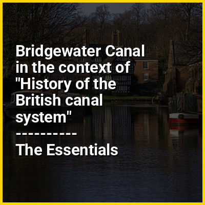
The Bridgewater Canal connects Runcorn, Manchester and Leigh, in North West England. It was commissioned by Francis Egerton, 3rd Duke of Bridgewater, to transport coal from his mines in Worsley to Manchester. It was opened in 1761 from Worsley to Manchester, and later extended from Manchester to Runcorn, and then from Worsley to Leigh.

The canal is connected to the Manchester Ship Canal via a lock at Cornbrook; to the Rochdale Canal in Manchester; to the Trent and Mersey Canal at Preston Brook, southeast of Runcorn; and to the Leeds and Liverpool Canal at Leigh. It once connected with the River Mersey at Runcorn but has since been cut off by a slip road to the Silver Jubilee Bridge. Following the re-routing of roads to the Silver Jubilee Bridge, the Runcorn Locks Restoration Society campaigns to reinstate the flight of locks.

↓ Menu

>>>PUT SHARE BUTTONS HERE<<<

👉 Bridgewater Canal in the context of History of the British canal system

The canal network of the United Kingdom played a vital role in the Industrial Revolution. The UK was the first country to develop a nationwide canal network which, at its peak, expanded to nearly 4,000 miles (6,400 kilometres) in length. The canals allowed raw materials to be transported to a place of manufacture, and finished goods to be transported to consumers, more quickly and cheaply than by a land based route. The canal network was extensive and included feats of civil engineering such as the Anderton Boat Lift, the Manchester Ship Canal, the Worsley Navigable Levels and the Pontcysyllte Aqueduct.

In the post-medieval period, some rivers were canalised for boat traffic. The Exeter Ship Canal was completed in 1567. The Sankey Canal was the first British canal of the Industrial Revolution, opening in 1757. The Bridgewater Canal followed in 1761 and proved to be highly profitable. The majority of the network was built in the "Golden Age" of canals, between the 1770s and the 1830s. From 1840, the canals began to decline, because the growing railway network was a more efficient means of transporting goods. From the beginning of the 20th century, the road network became progressively more important; canals became uneconomic and were abandoned. In 1948, much of the network was nationalised. Since then, canals have been increasingly used for recreation and tourism.

↓ Explore More Topics
In this Dossier

Bridgewater Canal in the context of Manchester Ship Canal

The Manchester Ship Canal is a 36-mile-long (58 km) inland waterway in the North West of England linking Manchester to the Irish Sea. Starting at the Mersey Estuary at Eastham, near Ellesmere Port, Cheshire, it generally follows the original routes of the rivers Mersey and Irwell through the historic counties of Cheshire and Lancashire before joining the latter at Salford Quays. Several sets of locks lift vessels about 60 ft (18 m) to the canal's terminus in Manchester. Landmarks along its route include the Barton Swing Aqueduct, the world's only swing aqueduct, and Trafford Park, the world's first planned industrial estate and one of the largest in Europe.

The rivers Mersey and Irwell were first made navigable in the early 18th century. Goods were also transported on the Runcorn extension of the Bridgewater Canal (from 1776) and the Liverpool and Manchester Railway (from 1830) but by the late 19th century the Mersey and Irwell Navigation had fallen into disrepair and was often unusable. Manchester's business community viewed the charges imposed by Liverpool's docks and the railway companies as excessive. A ship canal was proposed to give ocean-going vessels direct access to Manchester. The region was suffering from the Long Depression; the canal's proponents argued that the scheme would boost competition and create jobs. They gained public support for the scheme, which was first presented to Parliament as a bill in 1882. Faced with stiff opposition from Liverpool, the canal's supporters were unable to gain the necessary act of Parliament to allow the scheme to go ahead until 1885.

↑ Return to Menu

Bridgewater Canal in the context of Canal age

The Canal Age is a term of art used by science, technology, and industry historians. Various parts of the world have had various canal ages; the main ones belong to Egypt, Ancient Babylon, and the historical empires of India, China, Southeast Asia, and mercantile Europe. The successes of the Canal du Midi in France (1681), Bridgewater Canal in Britain (fully completed 1769), and Eiderkanal (superseded by today's Kiel Canal) in Denmark (later Germany) (1784) spurred on what was called in Britain "canal mania". In the Thirteen Colonies in 1762 legislation was passed supporting in the colonial-era Province of Pennsylvania to improve navigation on the Schuylkill River through Philadelphia.

Canals were critical industry, as until steam locomotives, canals were by the fastest way to travel long distances. Commercial canals generally had boatmen shifts that kept the barges moving behind mule teams 24 hours a day.
Cite error: There are <ref group=lower-alpha> tags or {{efn}} templates on this page, but the references will not show without a {{reflist|group=lower-alpha}} template or {{notelist}} template (see the help page).

↑ Return to Menu

Bridgewater Canal in the context of Trafford Park

Trafford Park is an area of the metropolitan borough of Trafford, Greater Manchester, England, opposite Salford Quays on the southern side of the Manchester Ship Canal, 3.4 miles (5.5 km) southwest of Manchester city centre and 1.3 miles (2.1 km) north of Stretford. Until the late 19th century it was the ancestral home of the Trafford family, who sold it to the financier Ernest Terah Hooley in 1896. Occupying an area of 4.7 square miles (12 km), it was the first planned industrial estate in the world, and remained the largest in Europe over a century later.

Trafford Park is almost entirely surrounded by water; the Bridgewater Canal forms its southeastern and southwestern boundaries, and the Manchester Ship Canal, which opened in 1894, its northeastern and northwestern boundaries. Hooley's plan was to develop the Ship Canal frontage, but the canal was slow to generate the predicted volume of traffic, so in the early days the park was largely used for leisure activities such as golf, polo and boating. British Westinghouse was the first major company to move in, and by 1903 it was employing about half of the 12,000 workers then employed in the park, which became one of the most important engineering facilities in Britain.

↑ Return to Menu

Bridgewater Canal in the context of Runcorn

Runcorn is an industrial town and cargo port within the Borough of Halton in Cheshire, England. It lies on the south bank of the River Mersey, where the estuary narrows to form the Runcorn Gap, and is located approximately 15 miles (24 km) southeast of Liverpool and 29 miles (47 km) southwest of Manchester. The Runcorn built-up area had a population of 61,145 at the 2021 census.

Runcorn was founded by Æthelflæd of Mercia in 915 AD as a fortification against the Viking invasion at a narrowing of the River Mersey. Under Norman rule, Runcorn fell under the Barony of Halton and an Augustinian abbey was established there in 1115. It remained a small and isolated settlement until the Industrial Revolution, when the 1776 extension of the Bridgewater Canal to Runcorn established it as a port linking coastal Liverpool with inland Manchester and Staffordshire. The docks enabled the growth of industry, initially shipwrights and sandstone quarries; in the late 18th and early 19th centuries, it was a spa and health resort, but this ended with the growth of polluting industries, especially soap and chemical works. In 1964, Runcorn was designated a new town and expanded eastward, absorbing neighbouring settlements and more than doubling its population.

↑ Return to Menu

Bridgewater Canal in the context of Barton Swing Aqueduct

The Barton Swing Aqueduct is a moveable navigable aqueduct in Barton upon Irwell, Greater Manchester, England. It carries the Bridgewater Canal across the Manchester Ship Canal. The swinging action allows large vessels using the ship canal to pass through and smaller craft, both narrowboats and broad-beam barges, to cross over the top. The aqueduct, the first and only swing aqueduct in the world, is a Grade II* listed building, and considered a major feat of Victorian civil engineering. Designed by Sir Edward Leader Williams and built by Andrew Handyside and Company of Derby, the swing bridge opened in 1894 and remains in regular use.

↑ Return to Menu

Bridgewater Canal in the context of Canal pound

A canal pound (from impound), reach, or level (American usage), is the stretch of level water impounded between two canal locks. Canal pounds can vary in length from the non-existent, where two or more immediately adjacent locks form a lock staircase, to many kilometres/miles.

The longest canal pound in the United Kingdom is on the Bridgewater Canal between the stop lock on the Trent and Mersey Canal at Preston Brook (Dutton Stop Lock No 76) and the start of the Leeds and Liverpool Canal near Leigh (Poolstock Bottom Lock No 2), a distance of 39.5 miles (63.6 km). Another long pound is on the Kennet and Avon Canal between Wootton Rivers Bottom Lock and Caen Hill top lock. The longest level on the Erie Canal in New York was the so-called '60 mile level' (actually 64.2 miles (103.3 km)) between Henrietta and Lockport.

↑ Return to Menu