Phú Thọ province in the context of Hồng Bàng dynasty


Phú Thọ province in the context of Hồng Bàng dynasty

⭐ Core Definition: Phú Thọ province

Phú Thọ is a province in northern Vietnam. Its administration center Việt Trì ward is located 80 kilometres (50 mi) from Hanoi and 50 kilometres (31 mi) from Nội Bài International Airport. The province covers an area of 9,631.38 km (3,718.70 sq mi) and, as of 2025, it had a population of 4,022,638.

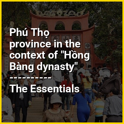
The history of Phú Thọ is linked to the 18 dynasties of Hùng kings who were credited with building the nation of Văn Lang. Because of its strategic location, the province is known as the "West Gate of Hanoi". It is located at the confluence of two large rivers: the Red River and the Da River, and in a transitional area between the Red River Delta the country's northern mountainous provinces. The Xuân Sơn National Park, established in February 2002, is located in the province about 80 kilometres (50 mi) from Việt Trì. The park covers an area of 15,048 hectares (37,180 acres), with over 11,000 hectares (27,000 acres) of natural forest and 1,396 hectares (3,450 acres) of limestone-mountain forests. Phú Thọ is one of the poorest areas of Vietnam and the poorest households earn below US$6 per person per month. Tea is important to the economy of the province. The Hung Kings temple complex, located on Nghĩa Lĩnh mountain in Việt Trì, is a complex of majestic architecture enclosing Hạ Temple (built in the 15th century), Thiện Quang pagoda, Giếng, Trung and Thuong temples, and King Hung's tomb.

↓ Menu
HINT:

In this Dossier

Phú Thọ province in the context of Yên Bái province

Yên Bái was a former province located in Northwest Vietnam. It shared borders with six provinces which are Hà Giang province, Lào Cai province, Lai Châu province, Sơn La province, Phú Thọ province, and Tuyên Quang province. The province covered an area of about 6,893 km (2,661 sq mi) and as of 2022 it had a population of 847,250 people.

Yên Bái's history is important under the French colony, particularly the subsequent "Yên Bái mutiny", an uprising of Vietnamese soldiers in the French colonial army on 10 February 1930 in collaboration with civilian supporters who were members of the Việt Nam Quốc Dân Đảng (VNQDD, the Vietnamese Nationalist Party).

View the full Wikipedia page for Yên Bái province
↑ Return to Menu

Phú Thọ province in the context of Tuyên Quang province

Tuyên Quang (Vietnamese: [tʷiə̄n kʷāːŋ]) is a province of Vietnam, located in the northeastern part of the country to the northwest of Hanoi, at the centre of Lô River valley, a tributary of the Red River. Its capital is Minh Xuân Ward. The province had a population of 1,865,270 in 2025, with a density of 137 persons per km over a total land area of 13,795.50 square kilometres (5,326.47 sq mi).

Tuyên Quang Province is bordered to the northeast by Cao Bằng Province, to the east by Thái Nguyên Province, to the south by Phú Thọ Province, to the west by Lào Cai Province, and to the north by Wenshan Zhuang and Miao Autonomous Prefecture, Yunnan Province and Baise City, Guangxi Zhuang Autonomous Region of China.

View the full Wikipedia page for Tuyên Quang province
↑ Return to Menu

Phú Thọ province in the context of Muong people

The Mường (Mường Bi dialect: mõl Mường; Vietnamese: người Mường) are an ethnic group native to northern Vietnam. The Mường is the country's third largest of 53 minority groups, with an estimated population of 1.45 million (according to the 2019 census). The Mường people inhabit a mountainous region of northern Vietnam centered in Hòa Bình Province and some districts of Phú Thọ province and Thanh Hóa Province. They speak the Mường language which is related to the Vietnamese language and the Thổ language and share ancient ethnic roots with the Vietnamese (Kinh) people.

View the full Wikipedia page for Muong people
↑ Return to Menu

Phú Thọ province in the context of Tuyên Quang Province

Tuyên Quang (Vietnamese: [tʷiə̄n kʷāːŋ]) is a province of Vietnam, located in the northeastern part of the country to the northwest of Hanoi, at the centre of Lô River valley, a tributary of the Red River. Its capital is Minh Xuân Ward. The province had a population of 1,865,270 in 2025, with a density of 137 persons per km over a total land area of 13,795.50 square kilometres (5,326.47 mi).

Tuyên Quang Province is bordered to the northeast by Cao Bằng Province, to the east by Thái Nguyên Province, to the south by Phú Thọ Province, to the west by Lào Cai Province, and to the north by Wenshan Zhuang and Miao Autonomous Prefecture, Yunnan Province and Baise City, Guangxi Zhuang Autonomous Region of China.

View the full Wikipedia page for Tuyên Quang Province
↑ Return to Menu