North Frisian Islands in the context of "Hindenburgdamm"

Play Trivia Questions online!

or

Skip to study material about North Frisian Islands in the context of "Hindenburgdamm"

Ad spacer

⭐ Core Definition: North Frisian Islands

The North Frisian Islands (German: Nordfriesische Inseln, pronounced [ˈnɔʁtˌfʁiːzɪʃə ˈɪnzl̩n]; Öömrang and Fering North Frisian: Nuurdfresk Eilunen; Söl'ring North Frisian: Nuurđfriisk Ailönen; Danish: Nordfrisiske Øer) are the Frisian Islands off the coast of North Frisia.

The term covers both the North Frisian Islands in the narrow sense (in Schleswig-Holstein, Germany) and the Danish Wadden Sea Islands (in Denmark). However, culturally and linguistically, the Danish islands are usually not reckoned as being part of North Frisia, since they are not inhabited by native speakers of the North Frisian language. Occasionally, the remote island of Heligoland is also included in this group for reasons of administrative convenience, despite not being located in the Wadden Sea, since the island is home to its own unique dialect of Frisian.

↓ Menu

>>>PUT SHARE BUTTONS HERE<<<

👉 North Frisian Islands in the context of Hindenburgdamm

The Hindenburgdamm or Hindenburg Dam is an 11 km (7 mile) long causeway joining the North Frisian island of Sylt to mainland Schleswig-Holstein. Its coordinates are 54°53′N 8°33′E / 54.883°N 8.550°E / 54.883; 8.550. It was opened on 1 June 1927 and is exclusively a railway corridor. The companies that built the Hindenburgdamm, a job that took four years, were Philipp Holzmann AG of Frankfurt, working from the mainland, and Peter Fix Söhne of Duisburg working from Sylt. A train trip along the causeway takes about 10 minutes, and the time between the auto terminals at Niebüll on the mainland and Westerland on Sylt is about 30 minutes. The Hindenburgdamm is part of the railway line known as the Marschbahn ("Marsh Railway"), which is double-tracked along much of the route, although there as yet exists a single-tracked stretch. On the causeway is a signal box. The rail line is not electrified making the use of diesel locomotives necessary. Trains coming from origins further south like Hamburg change from an electric locomotive to a diesel locomotive at Itzehoe.

Every day, more than 100 trains pass over the causeway, 50 of those ferrying cars (there is no road link to Sylt). Each year, the railway ferries more than 450,000 vehicles over the causeway.

↓ Explore More Topics
In this Dossier

North Frisian Islands in the context of Sylt

54°54′N 8°20′E / 54.900°N 8.333°E / 54.900; 8.333

Sylt (German pronunciation: [zʏlt] ; Danish: Sild; Söl'ring North Frisian: Söl) is an island in northern Germany, part of Nordfriesland district, Schleswig-Holstein, with a distinctively shaped shoreline. It belongs to the North Frisian Islands and is the largest island in North Frisia.The northernmost island of Germany, it is known for its tourist resorts, notably Westerland, Kampen and Wenningstedt-Braderup, as well as for its 40-kilometre-long (25-mile) sandy beach. It is frequently covered by the media in connection with its exposed situation in the North Sea and its ongoing loss of land during storm tides. Since 1927, Sylt has been connected to the mainland by the Hindenburgdamm causeway. In later years, it has been a resort for the German jet set and tourists in search of occasional celebrity sightings.

↑ Return to Menu

North Frisian Islands in the context of Frisian languages

The Frisian languages (/ˈfrʒən/ FREE-zhən or /ˈfrɪziən/ FRIZ-ee-ən) are a closely related group of West Germanic languages, spoken by about 400,000 Frisian people, who live on the southern fringes of the North Sea in the Netherlands and Germany. The Frisian languages are the closest living language group to the Anglic languages; the two groups make up the Anglo-Frisian languages group and together with the Low German dialects these form the North Sea Germanic languages. Despite the close genetic relationship between English and Frisian, the modern languages are not mutually intelligible. Geographical and historical circumstances have caused the two languages to drift apart linguistically.

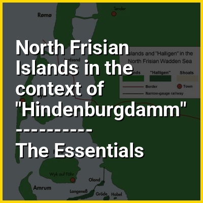
Frisian is traditionally divided into three branches often labeled distinct Frisian languages even though the dialects within each branch are not necessarily mutually intelligible. West Frisian is by far the most spoken of the three and is an official language in the Dutch province of Friesland, where it is spoken on the mainland and on two of the West Frisian Islands: Terschelling and Schiermonnikoog. It is also spoken in four villages in the Westerkwartier of the neighbouring province of Groningen. North Frisian, the second branch, is spoken in the northernmost German district of Nordfriesland in the state of Schleswig-Holstein, on the North Frisian mainland and on the North Frisian Islands of Sylt, Föhr, Amrum, and the Halligs. It is also spoken on the islands of Heligoland and Düne in the North Sea. The third Frisian branch, East Frisian, has only one remaining variant, Sater Frisian, spoken in the municipality of Saterland in the Lower Saxon district of Cloppenburg. Surrounded by bogs, the four Saterlandic villages lie just outside the borders of East Frisia, in the Oldenburg Münsterland region. In East Frisia proper, East Frisian Low Saxon is spoken today, which is not a Frisian language, but a variant of Low German/Low Saxon.

↑ Return to Menu

North Frisian Islands in the context of North Frisia

North Frisia (/ˈfrʒə/; German: Nordfriesland; North Frisian: Nordfraschlönj; Danish: Nordfrisland; Low German: Noordfreesland) is the northernmost portion of Frisia, located in Schleswig-Holstein, Germany, between the rivers Eider and Wiedau. It also includes the North Frisian Islands and Heligoland. The region is traditionally inhabited by the North Frisians.

↑ Return to Menu

North Frisian Islands in the context of Föhr

Föhr (German pronunciation: [føːɐ̯] ; Fering North Frisian: Feer; Danish: Før) is one of the North Frisian Islands on the German coast of the North Sea. It is part of the Nordfriesland district in the federal state of Schleswig-Holstein. Föhr is the second-largest North Sea island of Germany and a popular destination for tourists. A town and eleven distinct municipalities are located on the island. The climate is oceanic with moderate winters and relatively cool summers.

Being a settlement area already in Neolithic times, Föhr had been part of mainland North Frisia until 1362. Then the coastline was destroyed by a heavy storm flood known as Saint Marcellus's flood (Middle Low German: Grote Mandrenke, 'Great Drowning of Men') and several islands were formed, Föhr among them. The northern parts of Föhr consist of marshes while the southern parts consist of sandy geest. From the middle-ages until 1864, Föhr belonged to the Danish realm and to the Duchy of Schleswig, but was then transferred to Prussia as a result of the Second Schleswig War. Seafaring has long been the most popular trade, but farming and eventually tourism became the most important economic factors after the end of the Age of Sail. The island can be reached by a car and passenger ferry service or via an airstrip.

↑ Return to Menu

North Frisian Islands in the context of Amrum

Amrum (German pronunciation: [ˈamʁʊm] ; Öömrang North Frisian: Oomram) is one of the North Frisian Islands on the German North Sea coast, south of Sylt and west of Föhr. It is part of the Nordfriesland district in the federal state of Schleswig-Holstein and has approximately 2,300 inhabitants.

The island is made up of a sandy core of geestland and features an extended beach all along its west coast, facing the open North Sea. The east coast borders to mudflats of the Wadden Sea. Sand dunes are a characteristic part of Amrum's landscape, resulting in a vegetation that is largely made up of heath and shrubs. The island's only forest was planted in 1948. Amrum is a refuge for many species of birds and a number of marine mammals including the grey seal and harbour porpoise.

↑ Return to Menu

North Frisian Islands in the context of Halligs

The Halligen (German pronunciation: [ˈhalɪɡn̩] ; singular Hallig [ˈhalɪç] ) or the halliger (Danish, singular hallig) are small islands without protective dikes. They are variously pluralized in English as the Halligen, Halligs, Hallig islands, or Halligen islands. There are ten German halligen in the North Frisian Islands on Schleswig-Holstein's Wadden SeaNorth Sea coast in the district of Nordfriesland and one remaining hallig at the west coast of Denmark (Langli).

↑ Return to Menu