North Equatorial Current in the context of "Kuroshio Current Intrusion"

Play Trivia Questions online!

or

Skip to study material about North Equatorial Current in the context of "Kuroshio Current Intrusion"

Ad spacer

⭐ Core Definition: North Equatorial Current

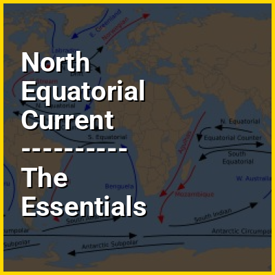
The North Equatorial Current (NEC) is a westward wind-driven current mostly located near the equator, but the location varies from different oceans. The NEC in the Pacific and the Atlantic is about 5°-20°N, while the NEC in the Indian Ocean is very close to the equator. It ranges from the sea surface down to 400 m in the western Pacific.

The NEC is driven by the north-hemisphere easterly trade wind. In couple with NEC, there is another current called South Equatorial Current (SEC), generated by the easterly trade wind in the southern hemisphere. Despite the well-coupled name of the two equatorial currents, the distribution of the NEC and the SEC is not in symmetry at the equator, but slightly northward to the equator. This asymmetric distribution is aligned to the location of the Intertropical Convergence Zone (ITCZ), which is the area that the northeast and the southeast trade wind converge.

↓ Menu

>>>PUT SHARE BUTTONS HERE<<<

👉 North Equatorial Current in the context of Kuroshio Current Intrusion

The Kuroshio Current is a northward flowing Western Boundary Current (WBC) in the Pacific Ocean. It is a bifurcation arm of the North Equatorial Current and consists of northwestern Pacific Ocean water. The other arm is the southward flowing Mindanao Current. The Kuroshio Current flows along the eastern Philippine coast, up to 13.7 Sv... of it leaking into the Luzon Strait - the gap between the Philippines and Taiwan - before continuing along the Japanese coast. Some of the leaked water manages to intrude into the South China Sea (SCS). This affects the heat and salt budgets and circulation and eddy generation mechanisms in the SCS. There are various theories about possible intrusion paths and what mechanisms initiate them.

↓ Explore More Topics
In this Dossier

North Equatorial Current in the context of Canary Current

The Canary Current is a wind-driven surface current that is part of the North Atlantic Gyre. This eastern boundary current branches south from the North Atlantic Current and flows southwest about as far as Senegal where it turns west and later joins the Atlantic North Equatorial Current. The current is named after the Canary Islands. The archipelago partially blocks the flow of the Canary Current (Gyory, 2007).

This wide and slow moving current is thought to have been exploited in the early Phoenician navigation and settlement along the coast of western Morocco and Old Spanish Sahara. The ancient Phoenicians not only exploited numerous fisheries within this current zone, but also established a factory at Iles Purpuraires off present day Essaouira for extracting a Tyrian purple dye from a marine gastropod murex species.

↑ Return to Menu

North Equatorial Current in the context of North Atlantic Gyre

The North Atlantic Gyre of the Atlantic Ocean is one of five great oceanic gyres. It is a circular ocean current, with offshoot eddies and sub-gyres, across the North Atlantic from the Intertropical Convergence Zone (calms or doldrums) to the part south of Iceland, and from the east coasts of North America to the west coasts of Europe and Africa.

In turn it is chiefly subdivided into the Gulf Stream flowing northward along the west; its often conflated continuation, the North Atlantic Current across the north; the Canary Current flowing southward along the east; and the Atlantic's North Equatorial Current in the south. The gyre has a pronounced thermohaline circulation, bringing salty water west from the Mediterranean Sea and then north to form the North Atlantic Deep Water.

↑ Return to Menu

North Equatorial Current in the context of Sargasso Sea

The Sargasso Sea (/sɑːrˈɡæs/) is a region of the Atlantic Ocean bounded by four currents forming an ocean gyre. It is the only named sea without land boundaries. It is distinguished from other parts of the Atlantic Ocean by its characteristic brown Sargassum seaweed and often calm blue water.

The sea is bounded on the west by the Gulf Stream, on the north by the North Atlantic Current, on the east by the Canary Current, and on the south by the North Atlantic Equatorial Current, the four together forming a clockwise-circulating system of ocean currents termed the North Atlantic Gyre. It lies between 20° and 35° north and 40° and 70° west and is approximately 1,100 kilometres (600 nautical miles) wide by 3,200 km (1,750 nmi) long. Bermuda is near the western fringes of the sea. While all of the above currents deposit marine plants and refuse into the sea, ocean water in the Sargasso Sea is distinctive for its deep blue color and exceptional clarity, with underwater visibility of up to 60 m (200 ft).

↑ Return to Menu

North Equatorial Current in the context of North Pacific Gyre

The North Pacific Gyre (NPG) or North Pacific Subtropical Gyre (NPSG), located in the northern Pacific Ocean, is one of the five major oceanic gyres. This gyre covers most of the northern Pacific Ocean. It is the largest ecosystem on Earth, located between the equator and 50° N latitude, and comprising 20 million square kilometers. The gyre has a clockwise circular pattern and is formed by four prevailing ocean currents: the North Pacific Current to the north, the California Current to the east, the North Equatorial Current to the south, and the Kuroshio Current to the west. It is the site of an unusually intense collection of human-created marine debris, known as the Great Pacific Garbage Patch.

The North Pacific Subtropical Gyre and the much smaller North Pacific Subpolar Gyre make up the two major gyre systems in the mid-latitudes of the Northern Pacific Ocean. This two-gyre circulation in the North Pacific is driven by the trade and westerly winds. This is one of the best examples of all of Earth's oceans where these winds drive a two-gyre circulation. Physical characteristics like weak thermohaline circulation in the North Pacific and the fact that it is mostly blocked by land in the north, also help facilitate this circulation. As depth increases, these gyres in the North Pacific grow smaller and weaker, and the high pressure at the center of the Subtropical Gyre will migrate poleward and westward.

↑ Return to Menu

North Equatorial Current in the context of Equatorial Counter Current

The Equatorial Counter Current is an eastward flowing, wind-driven current which extends to depths of 100–150 metres (330–490 ft) in the Atlantic, Indian, and Pacific Oceans. More often called the North Equatorial Countercurrent (NECC), this current flows west-to-east at about 3-10°N in the Atlantic, Indian Ocean and Pacific basins, between the North Equatorial Current (NEC) and the South Equatorial Current (SEC). The NECC is not to be confused with the Equatorial Undercurrent (EUC) that flows eastward along the equator at depths around 200 metres (660 ft) in the western Pacific rising to 100 metres (330 ft) in the eastern Pacific.

In the Indian Ocean, circulation is dominated by the impact of the reversing Asian monsoon winds. As such, the current tends to reverse hemispheres seasonally in that basin. The NECC has a pronounced seasonal cycle in the Atlantic and Pacific, reaching maximum strength in late boreal summer and fall and minimum strength in late boreal winter and spring. Furthermore, the NECC in the Atlantic disappears in late winter and early spring.

↑ Return to Menu