Lustrafjorden in the context of Skjolden


Lustrafjorden in the context of Skjolden
HINT:

👉 Lustrafjorden in the context of Skjolden

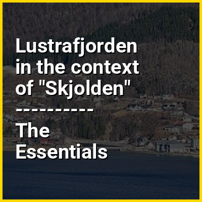
Skjolden is a village in Luster Municipality in Vestland county, Norway. It is located at the end of the Lustrafjorden, a branch of the Sognefjorden. Skjolden is located at the innermost point of the Sognefjorden (Norway's longest fjord). The length of the Sognefjorden is over 200 kilometres (120 mi) and it is measured from Skjolden to the island of Ytre Sula where the fjord meets the ocean. The valleys of Mørkridsdal and Fortunsdal meet at Skjolden, just west of the Hurrungane mountains.

The 0.51-square-kilometre (130-acre) village has a population (2025) of 238 and a population density of 467 inhabitants per square kilometre (1,210/sq mi).

↓ Explore More Topics
In this Dossier

Lustrafjorden in the context of Urnes stave church

Urnes Stave Church (Norwegian: Urnes stavkyrkje) is a 12th-century stave church at Ornes, along the Lustrafjorden, in Luster Municipality in Vestland county, Norway.

The church sits on the eastern side of the fjord, directly across the fjord from the village of Solvorn and about five kilometres (3 mi) east of the village of Hafslo. It is among the oldest stave churches in Norway, with parts of the lumber construction dating from the latter half of the 11th century. The church was built in a long church basilica plan inspired by medieval Christian churches, with cylindrical columns and semi-circular arches inside. The decoration on capitals of the columns and outside of the church embodies the visual evidence of the Viking culture’s transformation, assimilation, and adoption of Christianity. The north portal of the church is defined as the Urnes style, which contains decorations derived from Norwegian mythology dating back to the 12th century.

View the full Wikipedia page for Urnes stave church
↑ Return to Menu

Lustrafjorden in the context of Luster Municipality

Luster is a municipality in Vestland county, Norway. It is located at the end of the Sognefjorden in the traditional district of Sogn. The administrative centre is the village of Gaupne. Other villages in Luster include Fortun, Hafslo, Indre Hafslo, Jostedal, Luster, Nes, Ornes, Skjolden, Solvorn, and Veitastrond.

Luster is centered around the inner branch of the Sognefjord, which is called the Lustrafjorden. Its landscape includes fjords, steep mountains, water-abundant waterfalls, blue glaciers, and valleys. Both Jostedalsbreen National Park and Breheimen National Park are partially located in this municipality. The Sognefjellsvegen road goes over a mountain pass in eastern Luster.

View the full Wikipedia page for Luster Municipality
↑ Return to Menu