Kaliningrad in the context of "Kaliningrad Oblast"

Play Trivia Questions online!

or

Skip to study material about Kaliningrad in the context of "Kaliningrad Oblast"

Ad spacer

⭐ Core Definition: Kaliningrad

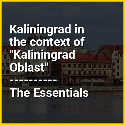
Kaliningrad (known as Königsberg until 1946) is the largest city and administrative centre of Kaliningrad Oblast, an exclave of Russia between Lithuania and Poland (663 kilometres (412 mi) west of the bulk of Russia). Located on the Pregolya River at the head of the Vistula Lagoon, it is the only ice-free Russian port on the Baltic Sea. Its population in 2020 was 489,359. Kaliningrad is the second-largest city in the Northwestern Federal District, after Saint Petersburg and the seventh-largest city on the Baltic Sea.

The city had been founded in 1255 on the site of the ancient Old Prussian settlement Twangste by the Teutonic Knights during the Northern Crusades, and named Königsberg ("king's mountain") in honor of King Ottokar II of Bohemia. A Baltic port city, it successively became the capital of the State of the Teutonic Order, the Duchy of Prussia and the provinces of East Prussia and Prussia. From 1454 to 1455, the city under the name of Królewiec belonged to the Kingdom of Poland, and from 1466 to 1657 it was a Polish fief. It was the coronation city of the Prussian monarchy, though the capital was moved to Berlin in 1701. Königsberg was the easternmost large city in Germany until World War II.

↓ Menu

>>>PUT SHARE BUTTONS HERE<<<

👉 Kaliningrad in the context of Kaliningrad Oblast

Kaliningrad Oblast (Russian: Калининградская область, romanizedKaliningradskaya oblastʹ) is the westernmost federal subject of Russia. It is a semi-exclave on the Baltic Sea within the historical Baltic region of Prussia, bordered by Poland to the south, Lithuania to the north and east, and the Baltic Sea to the west. The largest city and administrative centre is the city of Kaliningrad. The port city of Baltiysk is Russia's only port on the Baltic Sea that remains ice-free in winter. Kaliningrad Oblast had a population of roughly one million in the 2021 Russian census. It has an area of 15,125 square kilometres (5,840 sq mi).

Various peoples, including Lithuanians, Germans, and Poles, lived on the land which is now Kaliningrad. The territory was formerly the northern part of East Prussia. With the defeat of Nazi Germany in World War II, the territory was annexed to the Russian SFSR by the Soviet Union. Following the post-war migration and flight and expulsion of Germans, the territory was populated with Soviet citizens, mostly Russians.

↓ Explore More Topics
In this Dossier

Kaliningrad in the context of Königsberg

Königsberg is the historic German and Prussian name of the city now called Kaliningrad, Russia. The city was founded in 1255 on the site of the small Old Prussian settlement Twangste by the Teutonic Knights during the Baltic Crusades. It was named in honour of King Ottokar II of Bohemia, who led a campaign against the pagan Old Prussians, a Baltic tribe.

A Baltic port city, it successively became the capital of the State of the Teutonic Order, the Duchy of Prussia and the provinces of East Prussia and Prussia. Königsberg remained the coronation city of the Prussian monarchy from 1701 onwards, though the capital was Berlin. From the thirteenth to the twentieth centuries on, the inhabitants spoke predominantly German, although the city also had a profound influence upon the Lithuanian and Polish cultures. It was a publishing center of Lutheran literature; this included the first Polish translation of the New Testament, printed in the city in 1551, as well as the first book in Lithuanian and the first Lutheran catechism, both printed in Königsberg in 1547.

↑ Return to Menu

Kaliningrad in the context of East-Prussia

East Prussia (German: Ostpreußen [ˈɔstˌpʁɔɪ̯sn̩] ) was a province of the Kingdom of Prussia from 1772 to 1829 and again from 1878 (with the Kingdom itself being part of the German Empire from 1871); following World War I it formed part of the Weimar Republic's Free State of Prussia, until 1945. Its capital city was Königsberg (present-day Kaliningrad). East Prussia was the main part of the region of Prussia along the southeastern Baltic Coast.

The bulk of the ancestral lands of the Baltic Old Prussians were enclosed within the later province of East Prussia. During the 13th century, the native Prussians were conquered by the crusading Teutonic Knights. After the conquest they were gradually converted to Christianity. As a result of the medieval Ostsiedlung, Germans became the dominant ethnic group, while Poles and Lithuanians formed sizeable minorities. From the 13th century, the region of Prussia was part of the monastic state of the Teutonic Knights. After the Second Peace of Thorn in 1466 it became a part of the Kingdom of Poland, either directly (Warmia) or as a fief (remainder). In 1525, with the Prussian Homage, the territory became the Duchy of Prussia, a vassal duchy of Poland. It gained full sovereignty in 1657, when Poland renounced its feudal rights in the Treaty of Bromberg.

↑ Return to Menu

Kaliningrad in the context of Central Russia

Central Russia is, broadly, the various areas in European Russia.

Historically, the area of Central Russia varied based on the purpose for which it is being used. It may, for example, refer to European Russia (except the North Caucasus and Kaliningrad).

↑ Return to Menu

Kaliningrad in the context of Province of Prussia

The Province of Prussia (German: Provinz Preußen; Lithuanian: Prūsijos provincija; Polish: Prowincja Prusy; Kashubian: Prowincjô Prësë) was a province of the Kingdom of Prussia from 1824 to 1878. The province was established in 1824 from the provinces of West Prussia and East Prussia, and was dissolved in 1878 when the merger was reversed.

Königsberg (present-day Kaliningrad, Russia) was the provincial capital.

↑ Return to Menu

Kaliningrad in the context of Pravdinsk

Pravdinsk (Russian: Пра́вдинск, prior to 1946 known by its German name, Friedland, Polish: Frydląd, Lithuanian: Romuva), is a town and the administrative center of Pravdinsky District in Kaliningrad Oblast, Russia. It is on the Lava River and is 30 kilometers (19 mi) east of Bagrationovsk and 53 kilometers (33 mi) southeast of Kaliningrad. Population figures: 4,323 (2010 census); 4,480 (2002 census); 4,143 (1989 Soviet census).

↑ Return to Menu

Kaliningrad in the context of Wehlau

Znamensk (Russian: Зна́менск; German: Wehlau [ˈveːlaʊ] ; Lithuanian: Vėluva; Polish: Welawa) is a rural locality (a settlement) in Gvardeysky District of Kaliningrad Oblast, Russia, located on the right bank of the Pregolya River at its confluence with the Lava River 50 kilometers (31 mi) east of Kaliningrad. Population figures: 4,036 (2010 census); 4,302 (2002 census); 4,570 (1989 Soviet census).

↑ Return to Menu