Heligoland Bight in the context of "German Bight"

Play Trivia Questions online!

or

Skip to study material about Heligoland Bight in the context of "German Bight"

Ad spacer

⭐ Core Definition: Heligoland Bight

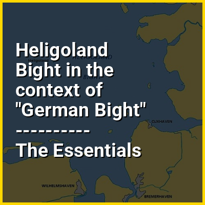
The Heligoland Bight, also known as Helgoland Bight, (German: Helgoländer Bucht, pronounced [ˈhɛlɡoˌlɛndɐ ˈbʊxt]) is a bay which forms the southern part of the German Bight, itself a bay of the North Sea, located at the mouth of the Elbe river. The Heligoland Bight extends from the mouth of the Elbe to the islands of Heligoland and lies between the East Frisian island of Wangerooge and the North Frisian peninsula of Eiderstedt.

The bight is named after Heligoland. It was the location of World War I naval battles in 1914 and 1917. In 1939 it also had a World War II aerial battle named after it.

↓ Menu

>>>PUT SHARE BUTTONS HERE<<<

👉 Heligoland Bight in the context of German Bight

The German Bight (German: Deutsche Bucht [ˈdɔʏtʃə ˈbʊxt]; Danish: tyske bugt; Dutch: Duitse bocht [ˈdœytsə ˈbɔxt]); West Frisian: Dútske bocht; North Frisian: Schiisk Bocht; sometimes also the German Bay) is the southeastern bight of the North Sea bounded by the Netherlands and Germany to the south, and Denmark and Germany to the east (the Jutland peninsula). To the north and west it is limited by the Dogger Bank. The Bight contains the Frisian and Danish Islands. The Wadden Sea is approximately ten to twelve kilometres (6 to 10 miles) wide at the location of the German Bight. The Frisian islands and the nearby coastal areas are collectively known as Frisia. The southern portion of the bight is also known as the Heligoland Bight. Between 1949 and 1956 the BBC Sea Area Forecast (Shipping Forecast) used "Heligoland" as the designation for the area now referred to as German Bight.

↓ Explore More Topics
In this Dossier

Heligoland Bight in the context of Heligoland

Heligoland (/ˈhɛlɪɡlænd/; German: Helgoland, pronounced [ˈhɛlɡoˌlant] ; Heligolandic Frisian: deät Lun, lit.'the Land', Mooring Frisian: Hålilönj, Danish: Helgoland) is a small archipelago in the North Sea, administratively part of the German state of Schleswig-Holstein. The islands are located in the Heligoland Bight (part of the German Bight) in the southeastern corner of the North Sea and are the only German islands not in the vicinity of the mainland: they lie approximately 69 kilometres (37+12 nautical miles) by sea from Cuxhaven at the mouth of the River Elbe.

The islands were historically possessions of Denmark, then became possessions of Great Britain from 1807 to 1890. Since 1890, they have been part of Germany, although after World War II they along with the rest of Schleswig-Holstein were administered by the United Kingdom as part of the British occupation zone in Germany. British control of Heligoland lasted until 1952, when it was turned over to the control of West Germany.

↑ Return to Menu