Fort de Chartres in the context of "Illinois Country"

⭐ In the context of the Illinois Country, Fort de Chartres was primarily significant as what type of outpost?

Ad spacer

⭐ Core Definition: Fort de Chartres

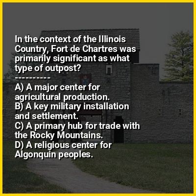
Fort de Chartres was a French fortification first built in 1720 on the east bank of the Mississippi River in present-day Illinois. It was used as the administrative center for the province, which was part of New France. Due generally to river flooding, the fort was rebuilt twice, the last time in limestone in the 1750s in the era of French colonial control over Louisiana and the Illinois Country.

The magazine (ammunition storehouse) of the fort is believed to be the oldest surviving building in Illinois. A partial reconstruction now exists of the limestone fort and the site is preserved as an Illinois state park, four miles (6 km) west of Prairie du Rocher in Randolph County, Illinois. Located on the floodplain area that became known as the American Bottom, the site is south of modern St. Louis. The forts were placed on the National Register of Historic Places and recognized as a National Historic Landmark on October 15, 1966. It was named one of the contributing properties to the French Colonial Historic District in 1974, along with other French-influenced sites such as the Creole House, the Pierre Menard House, the Kolmer Site (a former Indian village), and the site of Fort Kaskaskia.

↓ Menu

>>>PUT SHARE BUTTONS HERE<<<

👉 Fort de Chartres in the context of Illinois Country

The Illinois Country (French: Pays des Illinois [pɛ.i dez‿i.li.nwa]; lit.'land of the Illinois people'; Spanish: País de los ilinueses), also referred to as Upper Louisiana (French: Haute-Louisiane [ot.lwi.zjan]; Spanish: Alta Luisiana), was a vast region of New France claimed in the 1600s that later fell under Spanish and British control before becoming what is now part of the Midwestern United States. While the area claimed included the entire Upper Mississippi River watershed, French colonial settlement was concentrated along the Mississippi and Illinois Rivers in what is now the U.S. states of Illinois and Missouri, with outposts on the Wabash River in Indiana. Explored in 1673 from Green Bay to the Arkansas River by the Canadien expedition of Louis Jolliet and Jacques Marquette, the area was claimed by France. It was settled primarily from the Pays d'en Haut in the context of the fur trade, and in the establishment of missions from Canada by French Catholic religious orders. Over time, the fur trade took some French to the far reaches of the Rocky Mountains, especially along the branches of the broad Missouri River valley. The "Illinois" in the territory's name is a reference to the Illinois Confederation, a group of related Algonquian native peoples.

The Illinois Country was governed from the French province of Canada until 1717 when, by order of King Louis XV, it was annexed to the French province of Louisiana, becoming known as "Upper Louisiana". By the mid-18th century, major settlements included Cahokia, Kaskaskia, Chartres, Saint Philippe, and Prairie du Rocher, all on the east side of the Mississippi in present-day Illinois; and Ste. Genevieve across the river in what is now Missouri, as well as Fort Vincennes in what is now Indiana.

↓ Explore More Topics
In this Dossier

Fort de Chartres in the context of Saint Philippe, Illinois

St. Philippe is a former village in Monroe County, Illinois, United States. The settlement was founded in ca. 1723 by Frenchman, Philip Francois Renault, during the French colonial period. St. Philippe was strategically located near the bluffs that flank the east side of the Mississippi River in the vast Illinois floodplain known as the "American Bottom". The village was located three miles north of Fort de Chartres. Because of many decades of severe seasonal flooding, St. Philippe and the fort were both abandoned before 1765. After the British takeover of this area following their victory in the Seven Years War, many French from the Illinois country moved west to Ste. Genevieve, Saint Louis, and Missouri

↑ Return to Menu

Fort de Chartres in the context of French Colonial Historic District

The French Colonial Historic District is a historic district that encompasses a major region of 18th-century French colonization in southwestern Illinois. The district is anchored by Fort de Chartres and Fort Kaskaskia, two important French settlements and military posts in what was then the Illinois Country. The Kaskaskia village site is also included within the district; it includes the Pierre Menard House, the only surviving building from Illinois' first state capital. Over a dozen French houses in Prairie du Rocher are also part of the district, including the poteaux-sur-sol Creole House and the 1735 Meilliere House. In addition to the French sites, the district also includes several Native American archaeological sites, such as the Modoc Rock Shelter, the Kolmer Site, the Waterman Site, and the Henke Site.

The district was added to the National Register of Historic Places on April 3, 1974.

↑ Return to Menu