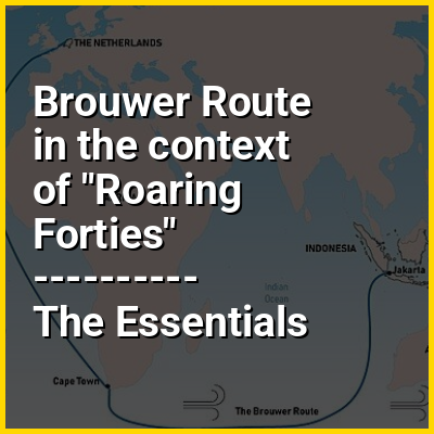
The Brouwer Route was a 17th-century route used by ships sailing from the Cape of Good Hope to the Dutch East Indies, as the eastern leg of the Cape Route. The route took ships south from the Cape (which is at 34° latitude south) into the Roaring Forties, then east across the Indian Ocean, before turning northeast for Java. Thus it took advantage of the strong westerly winds for which the Roaring Forties are named, greatly increasing travel speed.
The problem with the route was lack of an accurate way, at the time, to determine longitude, and thereby to know how far east a vessel had travelled. A sighting of either Amsterdam Island or Saint Paul Island was the only cue for ships to change direction and head north. However, this was reliant on the captain's expertise. Consequently, many ships were damaged by or wrecked on rocks, reefs, or islands on the western continental shelf of Australia, which was virtually unknown to Europeans at the time.