Amundsen Sea in the context of "West Antarctic Ice Sheet"

Play Trivia Questions online!

or

Skip to study material about Amundsen Sea in the context of "West Antarctic Ice Sheet"

Ad spacer

⭐ Core Definition: Amundsen Sea

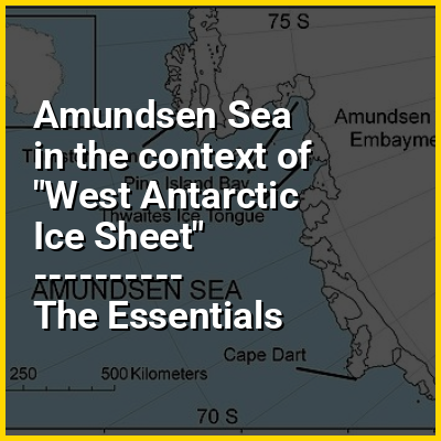
The Amundsen Sea is an arm of the Southern Ocean off Marie Byrd Land in western Antarctica. It lies between Cape Flying Fish (the northwestern tip of Thurston Island) to the east and Cape Dart on Siple Island to the west. Cape Flying Fish marks the boundary between the Amundsen Sea and the Bellingshausen Sea. West of Cape Dart there is no named marginal sea of the Southern Ocean between the Amundsen and Ross Seas. The Norwegian expedition of 1928–1929 under Captain Nils Larsen named the body of water for the Norwegian polar explorer Roald Amundsen while exploring this area in February 1929.

The sea is mostly ice-covered, and the Thwaites Ice Tongue protrudes into it. The ice sheet which drains into the Amundsen Sea averages about 3 km (1.9 mi) in thickness; roughly the size of the state of Texas, this area is known as the Amundsen Sea Embayment (ASE); it forms one of the three major ice-drainage basins of the West Antarctic Ice Sheet.

↓ Menu

>>>PUT SHARE BUTTONS HERE<<<

👉 Amundsen Sea in the context of West Antarctic Ice Sheet

78°44′03″S 133°16′41″W / 78.73417°S 133.27806°W / -78.73417; -133.27806

The West Antarctic Ice Sheet (WAIS) is the segment of the continental ice sheet that covers West Antarctica, the portion of Antarctica on the side of the Transantarctic Mountains that lies in the Western Hemisphere. It is classified as a marine-based ice sheet, meaning that its bed lies well below sea level and its edges flow into floating ice shelves. The WAIS is bounded by the Ross Ice Shelf, the Ronne Ice Shelf, and outlet glaciers that drain into the Amundsen Sea.

↓ Explore More Topics
In this Dossier

Amundsen Sea in the context of Thwaites Glacier

Thwaites Glacier is an unusually broad and vast Antarctic glacier located east of Mount Murphy, on the Walgreen Coast of Marie Byrd Land. It was initially sighted by polar researchers in 1940, mapped in 1959–1966 and officially named in 1967, after the late American glaciologist Fredrik T. Thwaites. The glacier flows into Pine Island Bay, part of the Amundsen Sea, at surface speeds which exceed 2 kilometres (1.2 mi) per year near its grounding line. Its fastest-flowing grounded ice is centered between 50 and 100 kilometres (31 and 62 mi) east of Mount Murphy. Like many other parts of the cryosphere, it has been adversely affected by climate change, and provides one of the more notable examples of the retreat of glaciers since 1850.

Thwaites Glacier is closely monitored for its potential to elevate sea levels. Since the 1980s, Thwaites and Pine Island Glacier have been described as part of the "weak underbelly" of the West Antarctic Ice Sheet, in part because they seem vulnerable to irreversible retreat and collapse even under relatively little warming, but mainly because if they go, the entire ice sheet is likely to eventually follow. This hypothesis is based on both theoretical studies of the stability of marine ice sheets and observations of large changes on these two glaciers. In recent years, the flow of both of these glaciers has accelerated, their surfaces have lowered, and their grounding lines have retreated. They are believed very likely to eventually collapse even without any further warming. The outsized danger Thwaites poses has led to some reporters nicknaming it the Doomsday Glacier, although this nickname is controversial among scientists.

↑ Return to Menu

Amundsen Sea in the context of Pine Island Glacier

Pine Island Glacier (PIG) is a large ice stream, and the fastest melting glacier in Antarctica. responsible for about 13% of Antarctica's ice loss. The glacier flows west-northwest along the south side of the Hudson Mountains into Pine Island Bay, part of the Amundsen Sea. The area drained by Pine Island Glacier comprises about 10% of the West Antarctic Ice Sheet. Satellite measurements have shown that the Pine Island Glacier Basin has a greater net contribution of ice to the sea than any other ice drainage basin in the world and this has increased due to recent acceleration of the ice stream. In recent years, the flow of the glacier has accelerated and the grounding line has retreated.

Since 2015, the calving of very large icebergs from the Pine Island Glacier has become a roughly annual event. The largest such iceberg, Iceberg B-46, had an initial size of 226 square kilometres (87 sq mi).

↑ Return to Menu

Amundsen Sea in the context of Bellingshausen Sea

The Bellingshausen Sea is an area along the west side of the Antarctic Peninsula between 57°18'W and 102°20'W, west of Alexander Island, east of Cape Flying Fish on Thurston Island, and south of Peter I Island (there the southern Vostokkysten). The Bellingshausen Sea borders the Eights Coast, the Bryan Coast, and the west part of the English Coast in Antarctica. To the west of Cape Flying Fish it joins the Amundsen Sea.

Bellingshausen Sea has an area of 487,000 km (188,000 sq mi) and reaches a maximum depth of 4.5 kilometers (2.8 mi). It contains the undersea plain Bellingshausen Plain.

↑ Return to Menu

Amundsen Sea in the context of Eights Coast

Eights Coast is a portion of the coast of West Antarctica, between Cape Waite and Pfrogner Point. To the west is the Walgreen Coast, and to the east is the Bryan Coast. It is part of Ellsworth Land and stretches between 103°24'W and 89°35'W. This coast is bordered by Thurston Island, Abbot Ice Shelf and some islands within the ice shelf, and for most of its length touches the Bellingshausen Sea (west of Thurston Island by the Amundsen Sea). Most of Eights Coast is not claimed by any nation. In the east, Eights Coast borders the sector claimed by Chile as part of its southernmost province. Peter I Island, 450 kilometers (280 miles) north of the coast, is claimed by Norway as a dependency.

The coast was sighted by members of the US Antarctic Service by flights from the USS Bear during February 1940. It was mapped in detail by the United States Geological Survey from surveys and from U.S. Navy air photographs, 1960–1966. Eights Coast was named by the Advisory Committee on Antarctic Names for James Eights of Albany, New York, a geologist on the ship Annawan during 1830, who performed geological investigations of the South Shetland Islands, and who cruised westward on the Annawan, in company with the ship Penguin, to 103°W. Eights, the earliest American scientist in the Antarctic, discovered the first known fossils in the Antarctic region, a tree section in the South Shetland Islands. As a result of these investigations Eights, during 1833, published in the Transactions of the Albany Institute (Vol. 2) what proved to be remarkably accurate observations and conclusions concerning the natural phenomena of the region.

↑ Return to Menu

Amundsen Sea in the context of Hudson Mountains

The Hudson Mountains are a mountain range in western Ellsworth Land just east of Pine Island Bay at the Walgreen Coast of the Amundsen Sea. They are of volcanic origin, consisting of low scattered mountains and nunataks that protrude through the West Antarctic Ice Sheet. The Hudson Mountains are bounded on the north by Cosgrove Ice Shelf and on the south by Pine Island Glacier. The mountains were volcanically active during the Miocene and Pliocene, but there is evidence for an eruption about two millennia ago and uncertain indications of activity in the 20th century.

↑ Return to Menu

Amundsen Sea in the context of Cape Flying Fish

Thurston Island (72°6′S 99°0′W / 72.100°S 99.000°W / -72.100; -99.000 (Thurston Island)) is a largely ice-covered, glacially dissected island, 135 nautical miles (250 km; 155 mi) long and 55 nautical miles (102 km; 63 mi) wide, lying between Amundsen Sea and Bellingshausen Sea a short way off the northwest end of Ellsworth Land, Antarctica.The island is separated from the mainland by Peacock Sound, which is occupied by the west portion of Abbot Ice Shelf.

↑ Return to Menu