Redlining in the context of Home Owners' Loan Corporation


Redlining in the context of Home Owners' Loan Corporation

⭐ Core Definition: Redlining

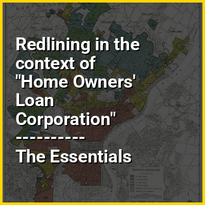
Redlining is a discriminatory practice in which financial services are withheld from neighborhoods that have significant numbers of racial and ethnic minorities. Redlining has been most prominent in the United States, and has mostly been directed against African Americans, as well as Mexican Americans in the Southwestern United States. The most common examples involve denial of credit and insurance, denial of healthcare, and the development of food deserts in minority neighborhoods.

Reverse redlining occurs when a lender or insurer targets majority-minority neighborhood residents with inflated interest rates by taking advantage of the lack of lending competition relative to non-redlined neighborhoods. The effect also emerges when service providers artificially restrict the supply of real estate available for loanable funds to nonwhites, thus providing alternative pretext for higher rates. Neighborhoods which were targeted for blockbusting were also subject to reverse redlining.

↓ Menu
HINT:

In this Dossier

Redlining in the context of Milwaukee

Milwaukee is the most populous city in the state of Wisconsin. Located on the western shore of Lake Michigan, it is the 31st-most populous city in the United States and the fifth-most populous city in the Midwest with a population of 577,222 at the 2020 census. The Milwaukee metropolitan area, with over 1.57 million residents, is the 40th-largest metropolitan area in the nation. It is the county seat of Milwaukee County.

Milwaukee was inhabited by many indigenous cultures, particularly the Potawatomi, Menominee, and Ho-Chunk. In the early 19th century, European settlers established the city as a hub for trade and industry, capitalizing on its location as a port. Its history was heavily influenced by Central European immigrants, and it remains a center of German-American culture. Milwaukee grew into a major brewing center, with the Miller, Pabst, and Schlitz breweries shaping its industrial identity. The city also became known for its strong labor movement. While it is an ethnically and culturally diverse city, it continues to be one of the most racially segregated cities as a result of early-20th century redlining.

View the full Wikipedia page for Milwaukee
↑ Return to Menu

Redlining in the context of Milwaukee, Wisconsin

Milwaukee is the most populous city in the state of Wisconsin. Located on the western shore of Lake Michigan, it is the 31st-most populous city in the United States and the fifth-most populous city in the Midwest with a population of 577,222 at the 2020 census. The Milwaukee metropolitan area, with over 1.57 million residents, is the 40th-largest metropolitan area in the nation. It is the county seat of Milwaukee County.

Milwaukee was inhabited by many indigenous cultures, particularly the Potawatomi, Menominee, and Ho-Chunk. In the early 19th century, European settlers established the city as a hub for trade and industry, capitalizing on its location as a port. Its history was heavily influenced by Central European immigrants, and it remains a center of German-American culture. Milwaukee grew into a major brewing center, with the Miller, Pabst, and Schlitz breweries shaping its industrial identity. The city also became known for its strong labor movement. While it is an ethnically and culturally diverse city, it continues to be one of the most racially segregated cities in the U.S. as a result of early-20th century redlining.

View the full Wikipedia page for Milwaukee, Wisconsin
↑ Return to Menu

Redlining in the context of Fair housing

Housing discrimination in the United States refers to the historical and current barriers, policies, and biases that prevent equitable access to housing. Housing discrimination became more pronounced after the abolition of slavery in 1865, typically as part of Jim Crow laws that enforced racial segregation. The federal government didn't begin to take action against these laws until 1917, when the Supreme Court struck down ordinances prohibiting African-Americans from occupying or owning buildings in majority-white neighborhoods in Buchanan v. Warley. However, the federal government as well as local governments continued to be directly responsible for housing discrimination through redlining and race-restricted covenants until the Civil Rights Act of 1968.

This Act included legislation known as the Fair Housing Act, which made it unlawful for a landlord to discriminate against or prefer a potential tenant based on their race, color, religion, gender, or national origin, when advertising or negotiating the sale or rental of housing. Such protections have also been extended to other "protected classes" including disabilities and familial status. Despite these efforts, studies have shown that housing discrimination still exists and that the resulting segregation has led to wealth, educational, and health disparities. The prevalence of housing discrimination and redlining in the United States has led to wide-ranging impacts upon various aspects of the structure of society, such as housing inequality and educational inequality. These phenomena can be seen through the lens of critical race theory as examples of systemic racism.

View the full Wikipedia page for Fair housing
↑ Return to Menu

Redlining in the context of East Palo Alto, California

East Palo Alto (/ˈst ˌpæl ˈælt/ EAST PAL-oh AL-toh; abbreviated E.P.A.) is a city in San Mateo County, California, United States. As of the 2020 census, the population of East Palo Alto was 30,034. It is situated on the San Francisco Peninsula, roughly halfway between the cities of San Francisco and San Jose. To the north and east is the San Francisco Bay, to the west is the city of Menlo Park, and to the south the city of Palo Alto. East Palo Alto was founded as an unincorporated community and was incorporated in July 1983. The two cities are separated only by San Francisquito Creek and, largely, the Bayshore Freeway (the vast majority of East Palo Alto is northeast of the freeway, while all of the residential part of Palo Alto is southwest of the freeway). The revitalization projects in 2000, and high income high-tech professionals moving into new developments, including employees from Google and Facebook, have begun to slowly eliminate the historically wide cultural and economic differences between the two cities. East Palo Alto and Palo Alto share both telephone area codes and postal ZIP codes.

In 1990, 43% of East Palo Alto's residents were African Americans, which was the result of redlining practices and racial deed restrictions in Palo Alto, while 34% were Latinos. As of 2020, African Americans were 11%, while Latinos are about 66%. A small minority of Pacific Islanders also reside in East Palo Alto, most of Tongan, Samoan, and Fijian origin.

View the full Wikipedia page for East Palo Alto, California
↑ Return to Menu