Intertidal in the context of "Littoral zone"

Play Trivia Questions online!

or

Skip to study material about Intertidal in the context of "Littoral zone"

Ad spacer

⭐ Core Definition: Intertidal

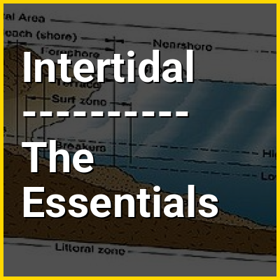
The intertidal zone or foreshore is the area above water level at low tide and underwater at high tide; in other words, it is the part of the littoral zone within the tidal range. This area can include several types of habitats with various species of life, such as sea stars, sea urchins, and many species of coral with regional differences in biodiversity. Sometimes it is referred to as the littoral zone or seashore, although those can be defined as a wider region.

The intertidal zone also includes steep rocky cliffs, sandy beaches, bogs or wetlands (e.g., vast mudflats). This area can be a narrow strip, such as in Pacific islands that have only a narrow tidal range, or can include many meters of shoreline where shallow beach slopes interact with high tidal excursion. The peritidal zone is similar but somewhat wider, extending from above the highest tide level to below the lowest. Organisms in the intertidal zone are well-adapted to their environment, facing high levels of interspecific competition and the rapidly changing conditions that come with the tides. The intertidal zone is also home to several species from many different phyla (Porifera, Annelida, Coelenterata, Mollusca, Arthropoda, etc.).

↓ Menu

>>>PUT SHARE BUTTONS HERE<<<
In this Dossier

Intertidal in the context of Rocky shore

A rocky shore is an intertidal area of seacoasts where solid rock predominates. Rocky shores are biologically rich environments, and are a useful "natural laboratory" for studying intertidal ecology and other biological processes. Due to their high accessibility, they have been well studied for a long time and their species are well known.

↑ Return to Menu

Intertidal in the context of Coralline algae

Coralline algae are red algae in the order Corallinales, characterized by a thallus containing calcareous deposits within its cell walls, giving it hardness. The colors of these algae are typically some hue of pink, or another shade of red, but some species can be purple, yellow, blue, white, or gray-green. Typically, these algae grow in a crustose manner (encrusting rocks and other hardscape); in the intertidal zone of rocky shorelines, and within coral reefs, these algae appear as an abundance of colorful patches on rock surfaces. Unattached specimens (maerl, rhodoliths) may form relatively smooth compact balls, or forming warty to fruticose thalli.

The red algae belong to the division Rhodophyta, within which the coralline algae form the order Corallinales. There are over 1600 described species of nongeniculate coralline algae. The corallines are presently grouped into two families on the basis of their reproductive structures. Most are marine, though one species lives in freshwater; Pneophyllum cetinaensis.

↑ Return to Menu

Intertidal in the context of Tidal pool

A tide pool or rock pool is a shallow pool of seawater that forms on the rocky intertidal shore. These pools typically range from a few inches to a few feet deep and a few feet across. Many of these pools exist as separate bodies of water only at low tide, as seawater gets trapped when the tide recedes. Tides are caused by the gravitational pull of the sun and moon. A tidal cycle is usually about 25 hours and consists of two high tides and two low tides.

Tide pool habitats are home to especially adaptable animals, like snails, barnacles, mussels, anemones, urchins, sea stars, crustaceans, octopus, and small fish, as well as seaweed. Inhabitants must be able to cope with constantly changing water levels, water temperatures, salinity, and oxygen content. At low tide, there is the risk of predators like seabirds. These pools have engaged the attention of naturalists and marine biologists, as well as philosophical essayists: John Steinbeck wrote in The Log from the Sea of Cortez, "It is advisable to look from the tide pool to the stars and then back to the tide pool."

↑ Return to Menu

Intertidal in the context of Mudflat

Mudflats or mud flats, also known as tidal flats or, in Ireland, slob or slobs, are coastal wetlands that form in intertidal areas where sediments have been deposited by tides or rivers. A global analysis published in 2019 suggested that tidal flat ecosystems are as extensive globally as mangroves, covering at least 127,921 km (49,391 sq mi) of the Earth's surface. They are found in sheltered areas such as bays, bayous, lagoons, and estuaries; they are also seen in freshwater lakes and salty lakes (or inland seas) alike, wherein many rivers and creeks end. Mudflats may be viewed geologically as exposed layers of bay mud, resulting from deposition of estuarine silts, clays and aquatic animal detritus. Most of the sediment within a mudflat is within the intertidal zone, and thus the flat is submerged and exposed approximately twice daily.

A recent global remote sensing analysis estimated that approximately 50% of the global extent of tidal flats occurs within eight countries (Indonesia, China, Australia, United States, Canada, India, Brazil, and Myanmar) and that 44% of the world's tidal flats occur within Asia (56,051 km or 21,641 sq mi). A 2022 analysis of tidal wetland losses and gains estimates that global tidal flats experienced losses of 7,000 km (2,700 sq mi) between 1999 and 2019, which were largely offset by global gains of 6,700 km (2,600 sq mi) over the same time period.

↑ Return to Menu

Intertidal in the context of Jamaica Bay Wildlife Refuge

Jamaica Bay Wildlife Refuge is a wildlife refuge in New York City managed by the National Park Service as part of Gateway National Recreation Area. It is composed of the open water and intertidal salt marshes and wetlands of Jamaica Bay. It lies entirely within the boundaries of New York City, divided between the boroughs of Brooklyn to the west and Queens to the east.

↑ Return to Menu

Intertidal in the context of Macrobenthos

Macrobenthos consists of the organisms that live at the bottom of a water column and are visible to the naked eye. In some classification schemes, these organisms are larger than 1 mm; in another, the smallest dimension must be at least 0.5 mm. They include polychaete worms, pelecypods, anthozoans, echinoderms, sponges, ascidians, crustaceans.

The marine macrobenthos community is a critical component and reliable indicator of the biotic integrity of marine ecosystems, especially the intertidal ecosystems. On the one hand, macrobenthos plays a vital role in maintaining ecosystem functions, such as material cycling in sediments and energy flow in food webs. On the other hand, macrobenthos is relatively sedentary and therefore reflects the ambient conditions of sediments, in which many pollutants (e.g., heavy metals and organic enrichment) are ultimately partitioned.

↑ Return to Menu