Buller Gorge in the context of Murchison, New Zealand


Buller Gorge in the context of Murchison, New Zealand

⭐ Core Definition: Buller Gorge

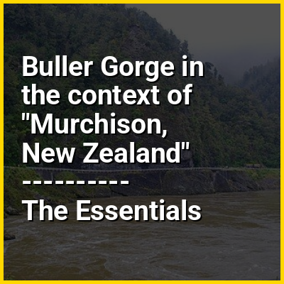
The Buller Gorge is a gorge located in the northwest of the South Island of New Zealand. The Buller River flows through the deep canyon between Murchison and Westport. Land Information New Zealand lists two sections for the gorge, Upper Buller Gorge and Lower Buller Gorge. State Highway 6 runs alongside, but considerably above, the river through the gorge. The Stillwater - Westport Line railway also runs through the gorge.

New Zealand's longest swingbridge at 110 metres (360 ft) in length spans the Buller River 14 kilometres (9 mi) west of Murchison. That area also offers rides on a zip-line across the gorge as well as several short bush walks.

↓ Menu
HINT:

In this Dossier

Buller Gorge in the context of Westport, New Zealand

Westport (Māori: Kawatiri) is a town in the West Coast region of the South Island of New Zealand. Established in 1861, it is the oldest European settlement on the West Coast. Originally named Buller, it is on the right bank and at the mouth of the Buller River, close by the prominent headland of Cape Foulwind. It is connected via State Highway 6 with Greymouth, 100 kilometres (62 mi) to the south, and with Nelson 222 kilometres (138 mi) in the northeast, via the Buller Gorge. The population of the Westport urban area was 4,600 as of June 2025. The Buller District had a population of 10,650.

View the full Wikipedia page for Westport, New Zealand
↑ Return to Menu

Buller Gorge in the context of Buller River

The Buller River (Māori: Kawatiri) is a river in the South Island of New Zealand. The Buller has the highest flow of any river in the country during floods, though it is only the 13th longest river; it runs for 177 km (110 mi) from Lake Rotoiti through the Buller Gorge and into the Tasman Sea near the town of Westport. A saddle at 710 m (2,330 ft) separates the Buller from the Motupiko River and that is divided from the Wairau River by a 695 m (2,280 ft) saddle, both aligned along the Alpine Fault, as is the top of the Buller valley.

Within the Buller Gorge and downstream from the Deepdale River joining, the Buller crosses from Tasman District into Buller District. The Paparoa Range separates the Buller River from the Grey River. A number of flora and fauna are found in the Buller catchment, many of these extending onto the slopes of the Paparoa Range.

View the full Wikipedia page for Buller River
↑ Return to Menu