Bilafond La in the context of Siachen Conflict


Bilafond La in the context of Siachen Conflict

⭐ Core Definition: Bilafond La

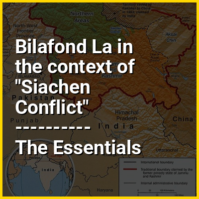
Bilafond La (meaning "Pass of the Butterflies" in Balti language), also known as the Saltoro Pass, is a mountain pass situated on Saltoro Ridge, sitting immediately west of the vast Siachen Glacier, some 40 km (25 mi) directly north of map point NJ9842 which defined the end of the 1972 Line of Control between Pakistan and India as part of the Simla Agreement. Bilafond La is on the ancient Silk Road linking the Indian subcontinent and China. It has been under Indian control since 1984.

The Saltoro Mountains Range, of which western slopes are held by Pakistan and separated by the Actual Ground Position Line (AGPL) the higher peaks and passes are held by India all of which remain snowbound throughout the year, provides access to Siachen Glacier to its east through five passes, i.e., listed from south to north are Chulung La (5,800m), Yarma La (6,100m), Gyong La (5,640m), Bilafond La (6,160m) - also called Saltoro La, and Sia La (7,300m). Bilafond La was a prominent feature during the 1984 start of military action in the Siachen Conflict between India and Pakistan. The Indian Army captured the pass in 1984 along with Sia La to the north and, in 1987, Gyong La to the south. India currently maintains a fortified military base at Bilafond La.

↓ Menu
HINT:

In this Dossier

Bilafond La in the context of Siachen Glacier

The Siachen Glacier is a glacier located in the eastern Karakoram range of the Himalayas, just northeast of the point NJ9842 where the Line of Control between India and Pakistan ends in northeastern Kashmir. At 76 km (47 mi) long, it is the longest glacier in the Karakoram and second-longest in the world's non-polar areas. It falls from an altitude of 5,753 m (18,875 ft) above sea level at its head at Indira Col on the India–China border down to 3,620 m (11,875 ft) at its terminus. The entire Siachen Glacier, with all major passes, has been under the administration of India as part of the union territory of Ladakh since 1984. Pakistan maintains a territorial claim over the Siachen Glacier and controls the region west of Saltoro Ridge, lying west of the glacier, with Pakistani posts located 1 km below more than 100 Indian posts on the ridge.

The Siachen Glacier lies immediately south of the great drainage divide that separates the Eurasian Plate from the Indian subcontinent in the extensively glaciated portion of the Karakoram sometimes called the "Third Pole". The glacier lies between the Saltoro Ridge immediately to the west and the main Karakoram range to the east. The Saltoro Ridge originates in the north from the Sia Kangri peak on the China border in the Karakoram range. The crest of the Saltoro Ridge's altitudes range from 5,450 to 7,720 m (17,880 to 25,330 feet). The major passes on this ridge are, from north to south, Sia La at 5,589 m (18,336 ft), Bilafond La at 5,450 m (17,880 ft), and Gyong La at 5,689 m (18,665 ft). The average winter snowfall is more than 1000 cm (35 ft) and temperatures can dip to −50 °C (−58 °F). Including all tributary glaciers, the Siachen Glacier system covers about 700 km (270 sq mi).

View the full Wikipedia page for Siachen Glacier
↑ Return to Menu

Bilafond La in the context of Siachen conflict

The Siachen conflict, sometimes referred to as the Siachen Glacier conflict or the Siachen War, was a military conflict between India and Pakistan over the disputed 1,000-square-mile (2,600 km) Siachen Glacier region in Kashmir. The conflict was started in 1984 by India's successful capture of the Siachen Glacier as part of Operation Meghdoot, and continued with Operation Rajiv in 1987. India took control of the 70-kilometre-long (43 mi) Siachen Glacier and its tributary glaciers, as well as all the main passes and heights of the Saltoro Ridge immediately west of the glacier, including Sia La, Bilafond La, and Gyong La. Pakistan controls the glacial valleys immediately west of the Saltoro Ridge. A cease-fire went into effect in 2003, but both sides maintain a heavy military presence in the area. The conflict has resulted in thousands of deaths, mostly due to natural hazards. External commentators have characterized it as pointless, given the perceived uselessness of the territory, and indicative of bitter stubbornness on both sides.

View the full Wikipedia page for Siachen conflict
↑ Return to Menu

Bilafond La in the context of Saltoro Ridge

The Saltoro Mountains form a subrange within the Karakoram Range and are situated in the southeastern part of the Karakoram. They lie on the southwest side of the Siachen Glacier, which is one of the two longest glaciers in the world outside the polar regions. The name "Saltoro" is also associated with the Saltoro Valley, located west of this range and descending on the Pakistani side of the Saltoro Range, which generally follows the Actual Ground Position Line (AGPL).

The Saltoro Range, of which western slopes are held by Pakistan and higher peaks and passes are held by India all of which remain snowbound throughout the year, provides access to Siachen Glacier to its east through five passes, i.e., listed from south to north are Chulung La (5,800m), Yarma La (6,100m), Gyong La (5,640m), Bilafond La (6,160m) - also called Saltoro La, and Sia La (7,300m). Saltoro Kangri peak, Saltoro River, and Saltoro Valley are features within the Saltoro Mountains range. The Actual Ground Position Line (AGPL) demarcates the boundary between the areas held by India and Pakistan in this region. In the Siachen area, India controls the high peaks and passes, while Pakistan occupies the lower peaks and valleys to the west.

View the full Wikipedia page for Saltoro Ridge
↑ Return to Menu

Bilafond La in the context of Sia La

Sia La is a mountain pass situated on Saltoro Ridge some 60 km (37 mi) north-northwest of map point NJ9842 which defined the end of the 1972 Line of Control between India and Pakistan as part of the Simla Agreement. Sia La is under Indian control and sits near the Line of Actual Control between India and China and is immediately northwest of the upper part of the vast Siachen Glacier, connecting that glacier to the Pakistani-controlled Kondus Glacier and valley to the west.

The Saltoro Mountains Range, of which western slopes are held by Pakistan and separated by the Actual Ground Position Line (AGPL) the higher peaks and passes are held by India all of which remain snowbound throughout the year, provides access to Siachen Glacier to its east through five passes, i.e., listed from south to north are Chulung La (5,800m), Yarma La (6,100m), Gyong La (5,640m), Bilafond La (6,160m) - also called Saltoro La, and Sia La (7,300m).

View the full Wikipedia page for Sia La
↑ Return to Menu

Bilafond La in the context of Gyong La

Gyong La is a mountain pass situated on Saltoro Ridge southwest of the vast Siachen Glacier, some 20 km (12 mi) directly north of map point NJ9842 which defined the end of the 1972 Line of Control between India and Pakistan. With Pakistan controlling areas just to the west along Chumik Glacier, the immediate Gyong La area has been under India's control since 1989. The Saltoro Mountains Range, of which western slopes are held by Pakistan and separated by the Actual Ground Position Line (AGPL) the higher peaks and passes are held by India all of which remain snowbound throughout the year, provides access to Siachen Glacier to its east through five passes, i.e., listed from south to north are Chulung La (5,800m), Yarma La (6,100m), Gyong La (5,640m), Bilafond La (6,160m) - also called Saltoro La, and Sia La (7,300m).

Dozens of Indian military tents and other equipment are visible at Gyong La in 2013 and 2016 Google Earth imagery 100 meters east, 670 meters northeast, and 2.7 km east-northeast of Gyong La, linked by clear trails. Nearer the former Pakistani "Naveed Top" position and 3.85 km west-northwest of Gyong La is a post and helipad is visible in 2001 and 2016 Google Earth imagery at 5,800 m (19,000 ft) elevation, higher than both the Indian positions and Gyong La.

View the full Wikipedia page for Gyong La
↑ Return to Menu

Bilafond La in the context of Operation Rajiv

Operation Rajiv was the codename for an Indian Army's June 1987 operation against Pakistan Army that successfully achieved its aim of snatching the highest point, called Left Shoulder (initially renamed as the Quaid Post by Pakistan and later renamed as Bana Top / Bana Post by India), to secure the Bilafond La sector along the Actual Ground Position Line (AGPL) on the Saltoro Mountain Range which is the western flank of the Siachen Glacier. Prior to this operation, India had captured the Siachen in 1984 and established Sonam Post and Amar Post in the Bilafond La sector, and Pakistan responded by establishing the Quaid Post in 1986 at a higher peak called the Left Shoulder (of Bilafond La). After Pakistan fired from the Quaid Post and killed Indian soldiers at the Sonam Post in 1986, India decided to capture the Quaid Post to secure the Bilafond La sector as the Quaid post was a threat to the Indian movement on the entire western Siachen Glacier. Consequently, under the Operation Rajiv in 1987 an Indian task force, led by Major Varinder Singh, launched multiple attacks on the Pakistani troops stationed at the post in an attempt to capture it. After several unsuccessful attempts, a team led by Naib Subedar Bana Singh successfully captured the Quaid Post. Following its capture, Quaid post was renamed to Bana Post after Naib Subedar (later Honorary Captain) Bana Singh, who led the operation. He was subsequently awarded the Param Vir Chakra, India's highest gallantry award, for his courage in this operation. Since then India continues to hold entire Bilafond La sector, including the Bilafond La itself.

View the full Wikipedia page for Operation Rajiv
↑ Return to Menu