Altinum in the context of Quarto d'Altino


Altinum in the context of Quarto d'Altino

⭐ Core Definition: Altinum

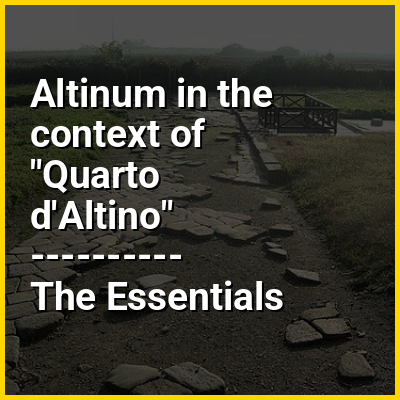
Altinum (in Altino, a frazione of Quarto d'Altino) was an ancient town of the Veneti 15 km southeast of modern Treviso, close to the mainland shore of the Lagoon of Venice. It was also close to the mouths of the rivers Dese, Zero and Sile. A flourishing port and trading centre during the Roman period, it was destroyed by Attila the Hun in 452. The town recovered, but was later abandoned when sea-borne sand began to cover it over. Its inhabitants moved to Torcello and other islands of the northern part of the lagoon.

Today Altinum is an archaeological area and has a national archaeological museum.

↓ Menu
HINT:

👉 Altinum in the context of Quarto d'Altino

Quarto d'Altino is a town in the Metropolitan City of Venice, Veneto, Italy.

The name "Quarto D'Altino" is composed by the prefix "Quarto" because the town was a quarter of a mile from the Roman city Altinum.

↓ Explore More Topics
In this Dossier

Altinum in the context of Via Annia

The Via Annia was the Roman road in Venetia in north-eastern Italy. It run on the low plains of the lower River Po and of the lower Veneto and Friuli-Venezia Giulia regions, an area which had many rivers and large marsh areas and bordered the coastal lagoons. It linked Atria (modern Adria) to Aquileia, passing through Patavium (modern Padua). Then it got to the mainland coast of the Lagoon of Venice near today's Mestre and passed through Altinum. After this, it went through Iulia Concordia (modern Concordia Sagittaria), which was further inland. It was paved only through the main towns. The rest was gravelled. It was six to eighteen metre wide. It played an important part in the Romanization of the region.

View the full Wikipedia page for Via Annia
↑ Return to Menu